


Gásadalur - Víkar


Link Copied!

-
 Up from the pass there is a good view down over the abandoned village Víkar. In the background in the middle of the picture, Reipsá can be seen, which runs down from Lake Fjallavatn. In the distant background to the left are the bird cliffs north of Vestmanna. Photo: Óli Gardshodn.
 -
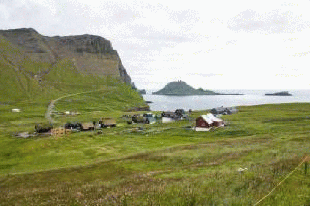 The village Gásadalur. Photo: Óli Gardshodn
 -
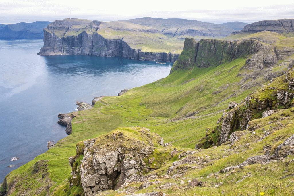
 We go all the way into the Gásadalur valley and further up the village path, which we see a little to the right in the picture. The pass that we must cross is 519 m. high. Photo: Óli Gardshodn
 -
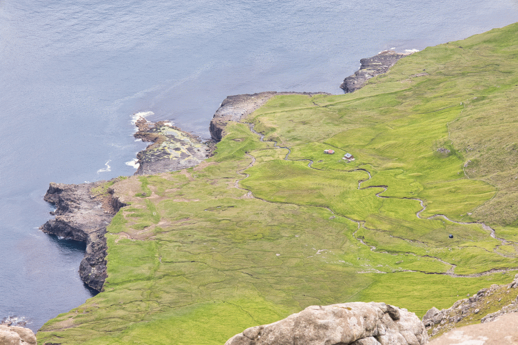 The abandoned village of Víkar. The ruins can be seen down the river in the middle of the picture. On the left side of the picture, down towards the beach cliff, the boat houses can be seen, from where they pulled the boats the 150 meters along the cliff down to the sea. Photo: Óli Gardshodn.
 -
 The village Víkar with the bird cliffs on Vágar and north of Vestmanna and by Saksun in the background. Farthest to the left is the characteristic mountain Snubburnar (623 m.) west of the place Sjeyndir. Photo: Óli Gardshodn
 -
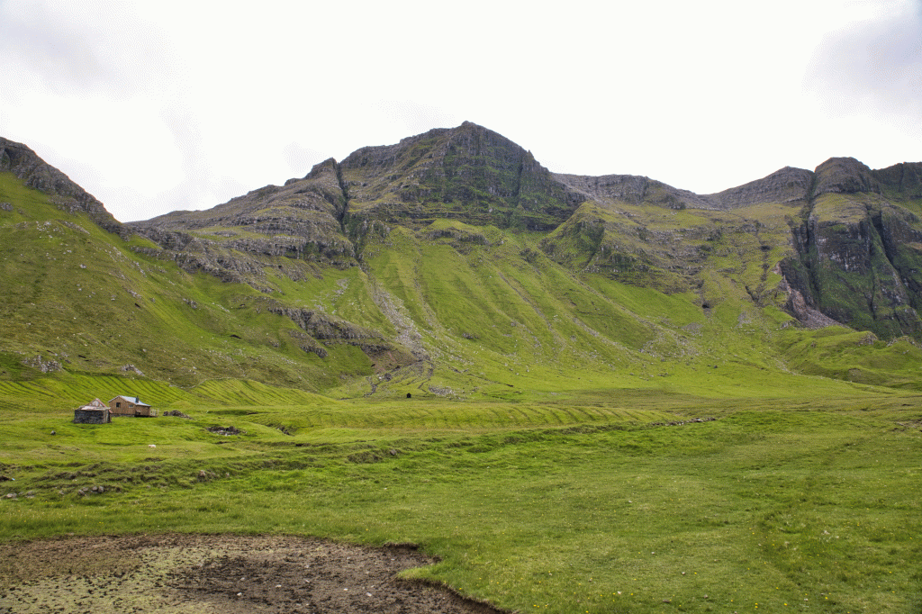 The village of Víkar. There are two paths up from the village. To the left up into the valley Sniðdal, through the gorge Neytagjógv, and to the right, up along the gorge Lambagjógv, to the village Gásadal. Photo: Óli Gardshodn.
 -
 Beachfront where they pulled the boats along. The boat houses are above the stones on the far right of the picture, for approx. 25 m. Height. Photo: Óli Gardshodn.
 -
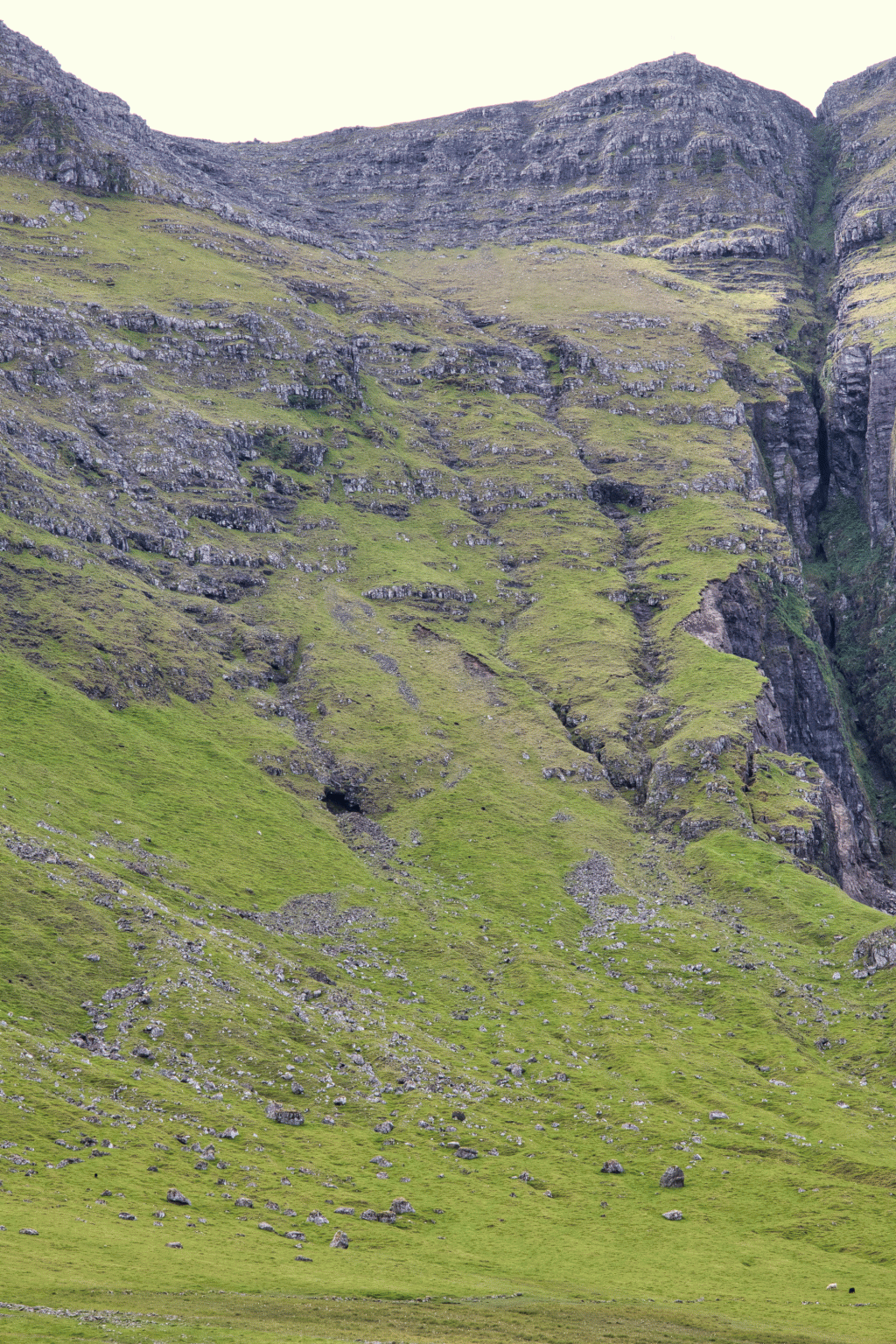 The village path up to the pass towards Gásadal. Although the mountainside is steep, it is good to walk here. But one must not go too close to the gorge Lambagjógv, because there is constant landslide. Photo: Óli Gardshodn
Ein avbjóðandi, vakur og spennandi túrur til avtoftaða bygd. Velti bøurin, gomlu toftirnar, hellan á Nevtanga og høgu fjøllini rundanum seta sín serliga dám.
Túrurin byrjar í Gásadali, har gingið verður eftir Slættanesgøtuni inn í dalin og haðani niðan á røðina millum Árnafjall og Eysturtind. Í sera grýtuta lendinum uppi á røðini, við varðan 150 m sunnan fyri Lambagjógv, skilir gøtan seg. Her verður farið eystureftir, omanav til Víkar. Á røðini, í 519 m hædd, er avbera vakurt útsýni yvir Vága-, Vestmanna- og Saksunarbjørgini umframt fjøllini norðast á Streymoynni. Á stóra slættanum beint undir okkum hava vit avtoftaðu bygdina Víkar.
grundin varð løgd undr bygdina í 1833, men av tí at trupult var at koma til og frá, so varð hon frágingin í 1914. Í 1855, tá ið fólkatalið var av tí mesta, búðu 16 fólk á Víkum í trimum húsum. Tey høvdu 6-8 mjólkkýr og seinni eisini oksar. Í fuglabjørgunum tætt hjá fleygaðu tey serliga nógvan lunda, sum tey onkuntíð eisini seldu.
Frá røðini sneiðir gøtan seg mestsum beint omaneftir, í ein landnyrðing. So við og við, sum vit ganga omaneftir, nærkast vit gjónni. Í uml. 300 m hædd koma vit oman í vallaða lendið, har gøtan fer at ganga javnari oman við gjónni.
Komin oman síggjast tvey gil, sum ganga oman sunnan fyri gjónna og møtast niðri á slættanum. Gakk oman millum hesi gilini. Beint omanfyri har sum gilini møtast, verður gingið eystur um tey og beinari oman til Víkar. Gøtan sæst ikki uppi í grýtuta lendinum, men tá ið komið er oman í vallaða lendið, fer hon at síggjast sneiða seg oman eftir rygginum millum gilini, uml. 60-80 m sunnanvert Lambagjógv.
Ansast skal eftir ikki at koma ov tætt Lambagjógv, tí har loypur árliga undan bakkanum. Ein stór riva er í lendinum millum niðasta part av Lambagjógv og ytra gilið, sum týðuliga vísir, at hetta kann rapla oman nær sum helst. Tískil má ikki ikki verða farið út um tað ytra gilið.
Ein góðan og turran dag á hásumri er øll gøtan oman til Víkar góð at ganga. Men av tí at tað er so grýtut í erva og hampiliga bratt allan vegin, er tað ikki egnað til smábørn og fólk, sum ikki eru von at ganga í sovorðnum lendi. Um tað gerst ov bratt og illgongt, ert tú allarhelst farin ov langt eystur frá Lambagjógv.
Eins og aðrastaðni er eisini á hesi leið eitt stað, teir kundu seta kistuna frá sær fyri at hvíla, tá ið lík varð borið millum Vík og Gásadal. Hetta er miðskeiðis í brøttu brekkuni, í 370 m hædd, uppi á einum stórum kneysa, kallaður á Kistu.
Komin oman á slættan verður gingið oman til búsetingina við Stórá. Húsini, sum nú standa har, eru ikki upprunahús, men hús hjá teimum, sum dagliga virka og hava seyð á Víkum og har um leiðir. Men gomlu toftirnar og velti bøurin sæst har, og meðan gingið verður runt í økinum, ber til at ímynda sær, hvussu tað man hava verið at búleikast her.
Líka so vakurt og friðsælt her er ein góðan summardag, líka so einsligt og harðbalið kann tað tykjast at hava verið kørgu vetrardagarnar. Tað er ikki sørt, at ein hevur hug at undrast á, hvat fekk fólk til at búseta seg á Víkum. Og við tungu og avbjóðandi farleiðini til nærmastu grannabygd Gásadals, og uppaftur tyngri til Bíggjar, hagar tey gingu til handils, er tað kanska ikki at undrast á, at fólkið fækkaðist. Seinasta húsið, sum bleiv reist á Víkum, bleiv niðurtikið, flutt og endurreist í Gásadali.
Ein góðveðurs summardag, har ongin uppgangur er, kann viðmælast at ganga ein túr oman móti Nevtanga, sum liggur niðan fyri høga, steyrrætta hamaran niðri á bakkanum. Her er útsýnið sera gott. Gangandi er oman um hamaran í vestara enda, við Nevið, har tvær neystagrundir standa. Tveir bátar vóru á Víkum, tá ið fólk búðu har. Undir hamaranum liggur henda ótrúliga stóra og langa, slætta hellan á Nevtanga. Á helluni liggja bert nakrir fáir stórir steinar inni undir hamaranum og ovast uppi undir vestara enda. Restin av helluni er ruddað fyri alt leyst tilfar.
Niðast á helluni síggjast nógvir størri og smærri hyljar, sum við sínum litríka grøntara mynda eitt vakurt framsýni til bjørgini undir Ritunøvu hinumegin vágna og norðurendan á Streymoynni. Bátarnir blivu drignir eftir allari hesi longu hellu. Manningin á Víkum var ikki stór, so tað var ein ógvuliga tungur dráttur.
Úr Víkum ganga vit aftur til Gásadals sama veg, sum vit komu.


Gásadal – Víkar - Gásadal
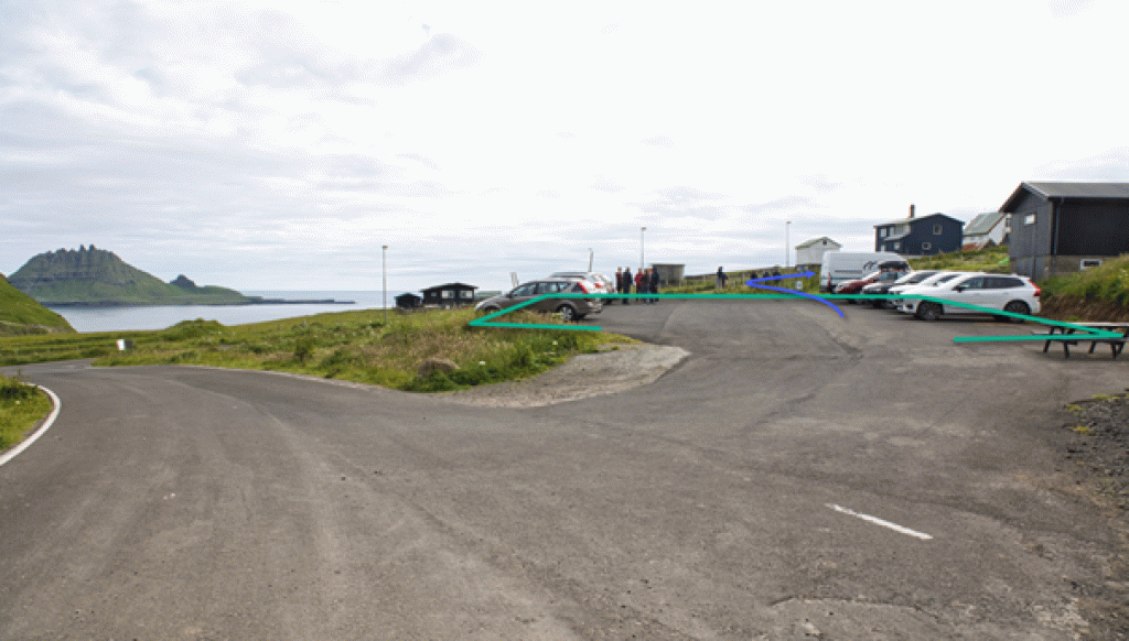
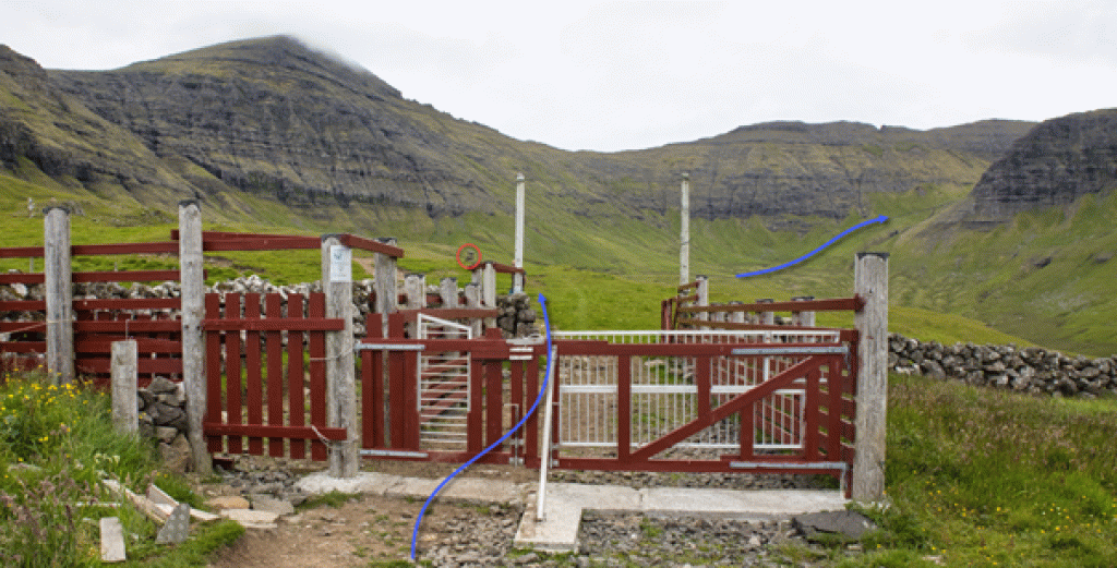
In Gásadal, there is decent parking in the middle of the village, with ample space and a public toilet—refer to the green markings. To reach the start of the route, please follow the blue arrows in the image below. Right outside the area by the stonewall gate, you can see the first cairn of the route through the valley:

Gásadalur - Víkar
Fakta

Tíð

longd

Hægsta stað

Hæddarmetrar
 Not suitable for children.
 Difficult
- We only recommend this route during decent weather and in the middle of summer. The route reaches up to 519-meter altitudes. Therefore, there should not be fog or risk of fog whilst arriving at Víkur, which will lead to the chance of not finding your way back over the mountain crest. The uppermost section of the hike, above Víkur, is steep and gravelly, and the path is not visible here. Outside of mid-summer, the trek is quite dangerous as there is not only a chance of frosty and slippy terrain but also the daylight period is too short. Therefore, we strongly recommend not conducting this trip outside the recommended times and recommend hiking with a knowledgeable guide.
Difficult
- We only recommend this route during decent weather and in the middle of summer. The route reaches up to 519-meter altitudes. Therefore, there should not be fog or risk of fog whilst arriving at Víkur, which will lead to the chance of not finding your way back over the mountain crest. The uppermost section of the hike, above Víkur, is steep and gravelly, and the path is not visible here. Outside of mid-summer, the trek is quite dangerous as there is not only a chance of frosty and slippy terrain but also the daylight period is too short. Therefore, we strongly recommend not conducting this trip outside the recommended times and recommend hiking with a knowledgeable guide.
 Grassy and decent terrain in Gásadal and Víkur; however, certain areas are steep and gravelly. This is especially the case on the side closer to Víkur, where the route’s highest point is quite steep and consists of loose gravel. In Gásadal, the terrain is wet in areas.
