


Hvalba - Trongisvágur


Link Copied!

-
 Up from the place Íslendingur, the view is both good and beautiful. Here we look in a north-westerly direction down to the settlement of Hvalba and the water Norðbergsvatn. At the top right is the promontory Villinganøs, where the villagers usually go up to see sunset and sunrise. Photo: Óli Gardshodn.
 -
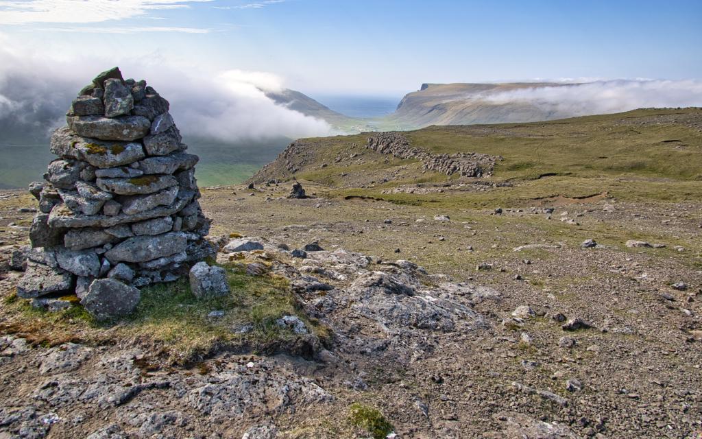 The cairn at the Sigmundarsteinar rocks, a short distance above the Káragjógv gorge. Photo: Óli Gardshodn.
 -
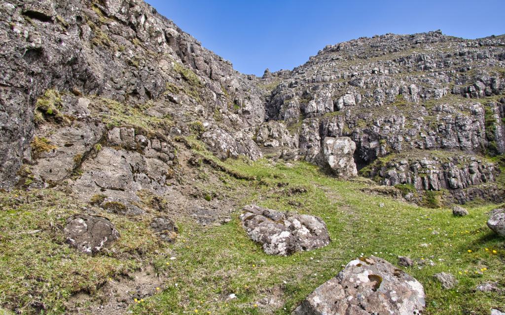 Káragjógv gorge. Photo: Óli Gardshodn.
 -
 View below the gorge Káragjógv over the fjord Hvalbiarfjørður, where we see the village of Nes on this side, and the village of Hvalba on the other side. Just below, on the left side of the picture, you can see the Prestgøtan path with its wide and straight stretch down to the mountain wall Litlhamar. Photo: Óli Gardshodn.
 -
 The view where the tour begins, 200 m west of the plantation in the village of Trongisvági. In the centre of the picture is the gorge Mannagjógv, through which the path goes up. Photo: Óli Gardshodn.
 -
 The view just below the gorge Mannagjogv towards the fjord Trongisvágsfjørður. To the right is the well-known mountain Oyrnafjall. The village path begins just west of the plantation, which we see in the middle of the picture. Photo: Óli Gardshodn.
 -
 The view from the village path down over the beautiful valley Vatnsdalur and the water Vatnsdalsvatn. In the middle, at the top of the picture, you can see the bird cliffs on the west side of the island of Skúvoy. Farthest in the background, the mountains of the northern islands, e.g., Skælingsfjall and Sornfelli. Photo: Óli Gardshodn.
Stórsligin og spennandi túrur niðan fram við tí brøttu Káragjógv og eftir slættanum á Hvalbiarfjalli
Ferðin byrjar við Fitjarnar vestan fyri Nes. Fylg hegninum millum bøin og hagan niðan á Lítlhamar. Uppi á hamaranum er steinløgd gøta, sum nú er vallað. Gøtan eitur Prestgøta, helst tí at hon er so breið, at ikki var neyðugt hjá presti at fara av rossinum.
Leiðin gongur niðan fram við Káragjógv, har søgnin sigur, at Kári prestur datt oman á rossabaki. Beint áðrenn tú kemur niðan til gjónna, deilir hon seg. Tak niðaru gøtuna, sum ikki er so brøtt og halt leiðina longur inn í gjónna fyri at njóta útsýnið niðan gjøgnum hana. Helt fram eftir gøtuni niðan fram við Káragjógv. Hóast tað summastaðni er eitt sindur bratt og í støðum leysur eyrur, so er gøtan góð at ganga. Tvær staðni er riðið undan gøtuni, men í góðveðri er tað ikki nøkur forðing. Men ver tó varin.
Hvalba og Sandvík eru millum elstu bygdir í Føroyum, og Hvalba er m.a. kend fyri síni kolanám.
Hvalba varð nógv herjað av sjórænarum í gomlum døgum. Søgur eru um eitt stórt álop í 1629, har sjórænarar rændu og myrdu nógv fólk. Annað av sjórænaraskipunum rendi á land í illveðri, og umleið 300 sjórænarar druknaðu. Økið, har teir eru grivnir, kallast Turkagravirnar og liggur við sjóvarmálan, stutt áðrenn tú kemur til Nes.
Í øldir var leiðin fram við Káragjógv, eftir Hvalbiarfjalli og oman gjøgnum Mannagjógv í Trongisvági ein av stóru samferðsluæðrunum og knýtti Suðuroynna saman við økinum norðanfjørðs. Fólk, sum komu við báti til Suðuroyar, løgdu at í Sandvík ella Hvalba og fóru so til gongu suður eftir oynni.
Ein onnur leið var inn í Botn og upp um Nakk. Hon var styttri og skjótari, men truplari hjá illa gongdum og ókunnufólki.
Ferðingin um Káragjógv minkaði munandi við Hvalbiartunlinum, sum kom í 1963. Hetta var fyrsti tunnil í Føroyum. Í mai 2021 læt ein nýggjur Hvalbiartunnil upp fyri ferðslu.
Komin niðaná sært tú Hvalbiarfjall framman fyri tær. Gakk eftir varðunum. Fyrsta høvdin, tú kemur til, er Lítli Íslendingur, og beint vestanfyri eru Sigmundarsteinar, sum Sigmundur Brestisson skal hava borið niðan. Søgnin sigur, at gongur tú millum steinarnar, gongur tú ikki av árinum.
Sigmundur var høvdingi í Føroyum uml. ár 1000 og er umrøddur í Føroyingasøgu. Hann búði í Skúvoy og kristnaði Føroyar við svørði í hond. Sambært søgnini svam Sigmundur úr Skúvoy til Sandvíkar – meginpartin av teininum við tveimum monnum á bakinum.
Mangt er borið og knossað upp um fjallið. Sagt verður, at fyrsta orglið, sum kom til Hvalbiar, varð borið um fjallið fyrst í 1890’unum. Orglið vigaði um 100 kilo.
Av Lítla Íslendingi og niðan á Íslending er javnt og slætt. Útsýnið er framúr. Tú sært bæði Lítlu Dímun, Stóru Dímun, Skúvoy, Sandoy og ein part av Hvalbiar bygd. Navnið Íslendingur kemur helst av, at varðin stendur høgur móti norðurættunum og verður skjótt ísklæddur í kulda og kava.
Annar varðin sunnan fyri Íslending hevur eina serliga søgu. Ein hvalbingur fór av Tvøroyri til Hvalbiar 1. des. 1917. Illveður við kavaroki brast á, og maðurin steðgaði við varðan. Fyri at halda hitanum fór hann at taka varðan niður og laða hann upp aftur. Maðurin varð funnin á lívi við varðan.
Av Íslendingi er góð og sløtt eyrgøta allan vegin til Mannagjógv. Her er friðsælt. Á leiðini sært tú oman í tann vakra Vatnsdal og Vatnsdalsvatn. Tveir hólmar eru á vatninum, har nógvur fuglur heldur til.
Vanliga plagdu fólk at rokna tveir tímar til teinin, men dømi eru um munandi skjótari ferðir um Hvalbiarfjall. Stutt eftir 1900 brúkti ein hvalbingur bert trý korter at renna úr Hvalba til doktarahúsini á Tvøroyri eftir heilivági til eitt sjúkt barn. Undir seinna heimsbardaga varð kappast á sama teini, og tá brúkti skjótasti maður 45 min. og 35 sekund um teinin.
Tá ið tú kemur til Mannagjógv, er stórsligið útsýni yvir allan Trongisvágsfjørð. Trongisvágur er gomul landbúnaðarbygd og eisini kend fyri kolagrevstur. Í 1800-talinum mentist keypsstaðurin Tvøroyri, og so líðandi vuksu bygdirnar saman.
Við Mannagjógv skilir gøtan seg, har tú kanst fara báðar vegir. Tað er torført at síggja har sum gøtan fer sundur, so ansa eftir hesum. Gøtan til høgru fer omaneftir á vestaru síðu á Mannagjógv – móti viðarlundini í Trongisvági, meðan gøtan til vinstru fer meira eysturyvir áðrenn hon kemur oman á høvuðsvegin 1 km. tættari Trongisvági. GPX fílan vísir ta vestaru leiðina, har parkeringsviðurskiftini eru betur. Í viðarlundini eru benkur og borð, har tað ber til at hugna sær við einum kaffimunni og hvíla seg eftir túrin.


Hvalba - Trongisvágur
The busroute 701 connects Tvøroyri and the ferry terminal in Krambatangi with the northern half of Suðuroy. See busschedules here:
https://www.ssl.fo/en/timetable/bus/701-famjin-tvoroyri-sandvik/
Parking is available nearby the starting point (see photo and map)


Trongisvágur - Hvalba
Plenty of parking is at the sports area, a 5 minutes walk away from the starting point. See also the parking obtions by the main road on the photo and map.


Hvalba - Trongisvágur
Trongisvágur - Hvalba
Fakta

Tíð

longd

Hægsta stað

Hæddarmetrar
 Suitable for children above 10 years old
 Difficult
- Steep and demanding to walk up along Káragjógv, but apart from this, the ground is flat and easy to walk. Tread carefully along Káragjógv, especially in freezing or wet conditions.
Difficult
- Steep and demanding to walk up along Káragjógv, but apart from this, the ground is flat and easy to walk. Tread carefully along Káragjógv, especially in freezing or wet conditions.
 Grass path most of the route, but some stones and rocks at Káragjógv.
